 |
||||||||||||||||||||
 |
||||||||||||||||||||
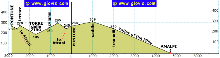
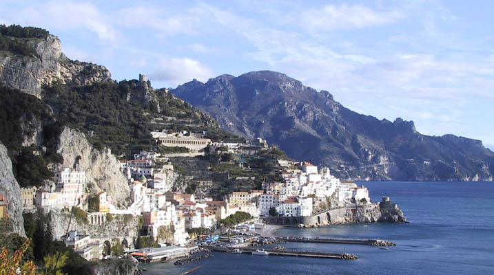
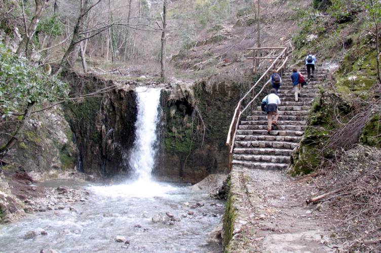
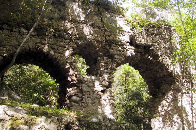
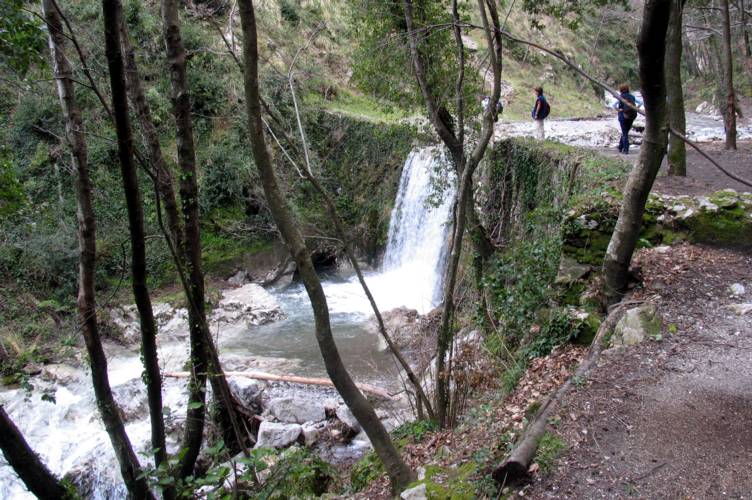
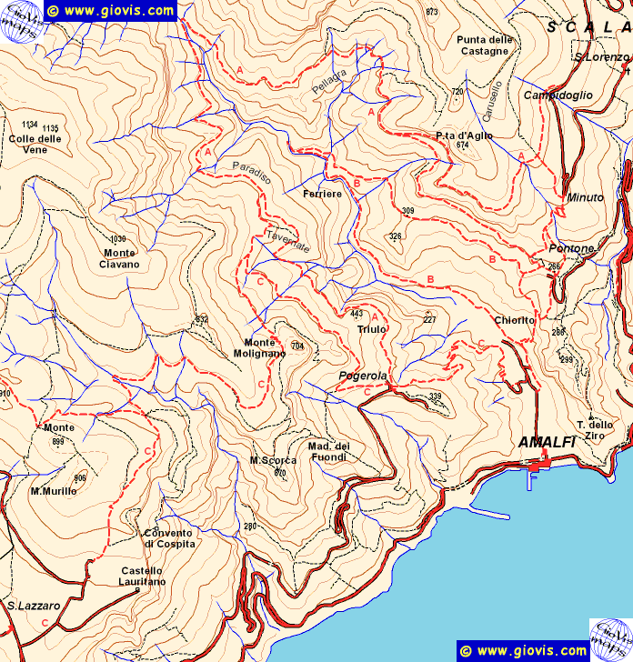
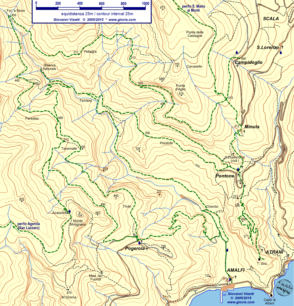
Solo pochi bus SITA andando da Amalfi a Ravello e Scala deviano per Pontone (266m, frazione di Scala). Di conseguenza probabilmente dovrete raggiungere questo piccolo centro a piedi da Ravello o da Scala (itinerari facili da seguire e ben tenuti). Si esce dalla piazzetta prendendo la mulattiera che passa sopra la fontanina e poi davanti alla trattoria Antico Borgo. Si segue il sentiero principale (in carta itinerario B) lasciando a destra le due ripide scalinate (che conducono rispettivamente a Minuta e alla parte alta della valle) e più avanti a sinistra, dopo un arco, l'inizio della lunga scalinata che porta ad Amalfi. Presso questo incrocio, nel periodo natalizio, viene allestito un originale presepe. Proseguendo in direzione dell'interno della valle si scendono ancora pochi scalini e poi inizia la dolce salita che ci condurrà, fra limoneti in stretti terrazzamenti e vigneti che coprono il sentiero, alla sella (309m) punto più alto di questa escursione. Di qui si percorre un sentiero lastricato di recente prima in ripida discesa e dopo aver superato il rivolo più o meno in quota (con minimi saliscendi) fino ad un piccolo edificio dell'acquedotto. Lo si oltrepassa e dopo pochi metri si deve scendere a sinistra; dopo qualche centinaio di metri si arriva alla Ferriera, si passa sotto l'arco dell'antico acquedotto, e si giunge in riva al torrente Canneto. Il sentiero in discesa prima dell'arco è quello che ci condurrà ad Amalfi passando al lato di numerosi altri ruderi, restando sempre da questo lato del torrente. Prima di scendere possiamo però effettuare una breve deviazione (ad anello) salendo al lato del greto fino ad arrivare nei pressi di un ponticello. Poco più a monte c'è la parte recintata della Riserva Integrale, noi giriamo invece a destra e torniamo camminando in quello che era il canale che portava l'acqua alla Ferriera ed è ora pieno di terra. Nei pressi dell'arco già descritto (dal quale l'acqua cadeva con forza sufficiente a muovere la forgia) lasciamo la gora e una scalinata un po' malandata ci permette di tornare al punto di partenza. La discesa ad Amalfi è ricca di interesse sia per i ruderi che per i panorami e, nell'ultima parte (lastricata), di nuovo i caratteristici limoneti amalfitani. Anche gli imponenti ruderi che si vedono nella parte finale, a traverso della valle, erano cartiere. Ad Amalfi c'è ancora una cartiera attiva e l'interessantissimo Museo della Carta; inoltre non dimenticate di visitare il Duomo ed il Chiostro del Paradiso.
|
|
Only a few SITA buses going from Amalfi to Ravello and Scala go to Pontone (266m, hamlet of Scala). You'll therefore probably reach this village on foot from Ravello or Scala (both are easy to follow and well kept itineraries) . Leave the square taking the mule track above the fountain, walking by the trattoria Antico Borgo. Follow the main path (on the map itinerary B) passing a couple of steep stairways on your right (the first leads to Minuta and the second to the higher trail) and about 100m ahead, just past an archway, you'll come to the steps going down to Amalfi. During Christmas time locals set up an original nativity scene alongside the paths meeting at this junction. Continuing towards the inner part of the valley go down a few more steps before starting the gentle ascent to the saddle (309m), the highest point of this excursion. You will walk through lemon groves on narrow terraces and under grape-vines growing on bowers over the path. From there go steeply down the recently limestone paved path; past the rivulet you'll walk mainly on the level until you reach a small stone cabin belonging to the acqueduct. Go past it and just a few meters uphill take the steps down to the left; a couple of hundred meters further on you'll come to the Ferriera (iron mill). Passing under the archway of the ancient acqueduct you'll get to the banks of the Canneto brook. The descending trail in front of the archway follows the left bank and will lead you to Amalfi passing several more ruined buildings. Before that you can also take a detour (a short loop) going up by the side of the river bed until you approach a small bridge. A little further upstream is the fenced off area of the Riserva Integrale (preserved area). Don't cross the brook but turn right walking back along the millrace that used to convey the water to the mill and is now filled up with earth. By the archway (from where water used to fall with sufficient force to move the forge) leave the duct and walk back down some dilapidated steps. The descent to Amalfi is very interesting for its ruined buildings (some paper mills, a limekiln, an old powerplant), for its views and (nearer to the town, where the path is paved) the characteristic lemon groves. The imposing buildings you can see across the lower part of the valley were also paper mills. In Amalfi there is an active mill still producing hand-made paper and an extremely interesting Paper Museum; don't forget to visit the Cathedral and the Cloister of Paradise.
|
||||||||||||||||||